
The Thomas Viaduct - Elkridge end of the bridge 1970.
Courtesy, The Library of Congress by William Edmund Barrett.
The Thomas Viaduct utilizes Roman-style stone arches using locally mined granite. The bridge is made up of 8 spans totaling 612 feet in length and is approximately 26 feet wide and 59 feet high from water level to the base of the track rails. It is built on a 4 degree curve which is achieved by building the piers in a wedge-shaped manner.
The Thomas Viaduct was designed by Benjamin Henry Latrobe II, then B&O's assistant engineer and who later became their chief engineer. Many at the time doubted whether Latrobe's design could even support itself much less the 6-7 ton locomotives being used at the time so they nicknamed the bridge "Latrobe's Folly".
Benjamin Latrobe reportedly suffered from insomnia and nervous disorders as he designed and oversaw construction of the bridge including shortness of breath, fainting and indigestion. Conventional treatments of the day included bleeding, cupping, purging, and drinking turpentine! Morphine and laudanum were commonly used for insomnia.

This is a lithograph from 1835 by Thomas Campbell. It was done the
same year that the Thomas Viaduct construction was completed so this
gives you a snapshot of how the area looked when the bridge was opened.
The Builders Monument can be seen at right on the Relay end and the 2-
flight staircase is barely visible on the left at the Elkridge end of the bridge.
Courtesy, Maryland Historical Society.
Construction began on July 4th, 1833 and the bridge was officially completed on July 4th, 1835 at a cost of approximately $200,000. Over 600 stone masons and free black men worked on the bridge and set up a camp on the Patapsco flats just downstream from the bridge site. Locally mined granite from Ellicott's Mills was shipped via the Old Main Line on railroad cars and delivered right to the construction site.
The bridge was named after Philip E. Thomas who was the first president of the Baltimore and Ohio Railroad (B&O). A 15 foot tall obelisk stands today on the Relay end of the bridge, designating government and railroad officials connected to the project.
Today the bridge carries 200 ton diesel locomotives and heavy freight traffic on a daily basis. The Thomas Viaduct has been in service, without interruption, since the day that it was opened in 1835. It survived the great flood of 1868 as well as Hurricane Agnes in 1972, two floods that wiped out the Patapsco Valley and destroyed nearly everything in their path.
The Thomas Viaduct was designated a National Historic Landmark on January 28, 1964, and administratively listed on the National Register of Historic Places on October 15, 1966. The bridge has also been named a National Historic Civil Engineering Landmark by the American Society of Civil Engineers (ASCE).

Oil painting by John H.B. Latrobe of the Thomas Viaduct circa 1850-1860.
Courtesy of the Maryland Historical Society #1945-105-4.
**I'd like to point out an interesting fact about
the historic paintings, lithographs & photos**
You may notice that the very early pictures of the viaduct tend to make the bridge appear taller and a bit more graceful in it's overall appearance than it does today. It took me much longer than it should have to figure out why. The Patapsco River gorge has silted up significantly over the past almost 2 centuries. The soil all around the the bridge piers is a spongy coarse sand in consistency. I counted the number of granite blocks above ground level on several different bridge piers and found that they are buried anywhere from 3-4 feet to as much as over 8+ feet deep in silt compared with photos of the same piers 130 years ago.
This is nothing new though. Elkridge Landing (now the town of Elkridge) was just a thousand yards downstream from the Thomas Viaduct. Two hundred and fifty years ago Elkridge Landing was a busy colonial river port rivaling old Annapolis. The river there was as wide as 500 feet across and 20 feet deep. English ships sailed up the Patapsco river from Baltimore to pick up "hogsheads" of tobacco that were locally grown at the time. The river began to silt up due to ships dropping their ballast in the river before picking up cargo, mining and agriculture upriver, and occasional floods (known as "freshets") which finally made it impossible to navigate and the port ceased to exist.
There was a small steamboat that was able to navigate up the Patapsco river as far as the Thomas Viaduct which stopped at a wharf just below the bridge. The 1868 flood wiped-out the wharf and filled in the steam boat channel with silt.
Today, much of the river in the Elkridge/Relay area is little more than a shallow creek that couldn't accommodate anything larger than a row boat. Also worth noting is that much less water flows down the Patapsco River today due to Liberty Reservoir and its 160 foot high dam that was completed in 1954.
So if the Thomas Viaduct looks a little on the short and stubby side to you today, it actually is.
**Click On Any Photograph To Enlarge It**

A wide-angle view of the outer curve side of the bridge showing all 8
spans. Photograph circa 1975. Courtesy of the History Room of the
Baltimore County Public Library Catonsville Branch.

Baltimore County Public Library Catonsville Branch.

A 1970's aerial view of the outer curve of the Thomas Viaduct from a
Library of Congress photograph. Floods tend to shift the course of the
river at the bridge. The Patapsco river tends to flow under the 3rd, 4th
&/or 5th spans of the bridge today (counting from left to right).
river at the bridge. The Patapsco river tends to flow under the 3rd, 4th
&/or 5th spans of the bridge today (counting from left to right).
The dark line that looks like a dried up stream bed running diagonally
from the left bottom corner just below the tree tops in the foreground
looks to be the remnants of the mill race for the old Hockley Grist Mill
that ran from a small mill dam (just out of view upstream to the left)
and then under the first bridge span on the right. The mill was just
on the other side of the bridge. It burned down in 1883.

massive damage. Notice how clear the area around the bridge
is from the flood. Photo by blog follower Walt Hiteshew.
Thanks for sharing Walt.
The Thomas Viaduct in 1972. Tropical Storm Agnes had
flooded the Patapsco River Valley in June of 1972 and did massive damage. Notice how clear the area around the bridge
is from the flood. Photo by blog follower Walt Hiteshew.
Thanks for sharing Walt.
Oil painting by John H.B. Latrobe of the Thomas Viaduct circa 1850-1860.
Courtesy of the Maryland Historical Society #1945-105-4.

 Thomas Viaduct in 1880. This picture was taken from a
hilltop where a Union Army artillery battery was placed
during the Civil War to protect the bridge. The Hockley
grist mill with a connecting ramp at the tracks is at right
in the foreground. It burned down in 1883. The Viaduct
Hotel with the obelisk in front of it can be seen at the far
end of the bridge. Photo credit Patapsco Valley State
Park, courtesy of the Baltimore County Public Library
Legacy Web project.
 A close-up of the Hockley Grist Mill taken from the Thomas Viaduct.
The bridge railing is at bottom right. Notice the viaduct stairs in front
of the railing at bottom right. Levering Avenue today runs under where
the grain chutes from the tracks are. Photo donated by John McGrain,
courtesy of Brennan Harrington.


Photo showing the original pedestrian bridge over the river. Each span
of the Thomas Viaduct is about 58 feet long so the little bridge is over
120 feet long with the ramps leading up to it. The split rail fence in the
foreground shows the human scale. If you click on the photo to enlarge
it you can see the telegraph poles running across the top that are visible
in Civil War photos of the Thomas Viaduct. The 1872 photo below
shows only pieces of the stone pilings from the foot bridge. Photograph
donated to the blog by John McGrain. Photo circa.1860's before the
great flood of 1868.

see the remnants of pilings from what was a foot bridge attached
to the viaduct's piers on the first 3 spans. There is also a roof and
wall of a building visible under the first span. Photo B&O Railroad
Museum.
 Photo taken from the same vantage point in 2014. Photo by
Jeff L. March 22, 2014.


The Thomas Viaduct 1861 from the bluff where a Union artillery
battery was placed. Notice the man standing at bottom left. Union
Fort Dix was located behind the photographer. Courtesy of the
Howard County Historical Society.

hilltop where a Union Army artillery battery was placed
during the Civil War to protect the bridge. The Hockley
grist mill with a connecting ramp at the tracks is at right
in the foreground. It burned down in 1883. The Viaduct
Hotel with the obelisk in front of it can be seen at the far
end of the bridge. Photo credit Patapsco Valley State
Park, courtesy of the Baltimore County Public Library
Legacy Web project.

The bridge railing is at bottom right. Notice the viaduct stairs in front
of the railing at bottom right. Levering Avenue today runs under where
the grain chutes from the tracks are. Photo donated by John McGrain,
courtesy of Brennan Harrington.

This one was taken from the same hilltop, circa 1890's - early1900's.
Photo is from an e-book of The Modern Railroad by Edward Hungerford.
A whimsical painting of the Thomas Viaduct with the
Viaduct Hotel train station in the background.
Oil on canvas by Stephens Berge ca. 1934-35. In 1930, Stephens
and his twin Henry, graduated from the Maryland Institute of Art, one
as a painter and the other a sculptor. Both worked full time at their
professions. Their father, Edward Berge, was a well-known sculptor.
The Berge brothers were good friends with Dolly Davis as well the
Bahrs. Stevens died in his late seventies ca.1986. A memorial show
for his work was held at the McDonogh School Galleries. Florence
and Leonard Bahr bought this painting then, and presented it to the
Elkridge Heritage Society - Sept. 12, 1989.

Thomas Viaduct with a passenger train after a snow storm in 1880.
Courtesy of the Baltimore County Public Library Legacy Web project.
 A watercolor done by Baltimore artist Hugh Newell in 1885. Mr.
Newell was living in Baltimore at the time of this painting and was
teaching at the Maryland Institute College of Art. Blog follower
T. Sean Daugherty owns this painting and was kind enough
share it.

Newell was living in Baltimore at the time of this painting and was
teaching at the Maryland Institute College of Art. Blog follower
T. Sean Daugherty owns this painting and was kind enough
share it.

of the Thomas Viaduct is about 58 feet long so the little bridge is over
120 feet long with the ramps leading up to it. The split rail fence in the
foreground shows the human scale. If you click on the photo to enlarge
it you can see the telegraph poles running across the top that are visible
in Civil War photos of the Thomas Viaduct. The 1872 photo below
shows only pieces of the stone pilings from the foot bridge. Photograph
donated to the blog by John McGrain. Photo circa.1860's before the
great flood of 1868.

Thomas Viaduct - Relay end of the bridge in 1872. The rebuilt
Hockley Mill can be seen at center left. There was a huge flood
in 1868 that wiped-out the entire Patapsco River valley. Notice
how the vegetation is practically non-existent in the river gorge
4 years later. If you click on the photo to enlarge it you can clearly see the remnants of pilings from what was a foot bridge attached
to the viaduct's piers on the first 3 spans. There is also a roof and
wall of a building visible under the first span. Photo B&O Railroad
Museum.

Jeff L. March 22, 2014.

The Thomas Viaduct at the Relay end of the bridge 1886. Notice
the people having a picnic next to a lone tree in the foreground and
several men fishing on the far shore. There is also a person looking
down from the bridge walkway. The walkway was installed sometime
after the 1868 flood destroyed the small foot/cart bridge shown in the
above drawing. Notice also that there still are no shrubs and only a
single tree present around the bridge 18 years after the flood. Photo
courtesy of the Baltimore County Public Library Legacy Web project.

The same angle of the bridge today. The scrubby little trees that grow
all around the bridge block most of the views that were available 125
years ago. Notice that the river has shifted it's course over the years and
no longer flows under the same spans as it did in the previous picture.
Photograph by Jeff L. April 2011.
 Thomas Viaduct at the Elkridge end of the bridge 1886. Again, the flood
damage from almost 20 years prior is obvious. Courtesy of the Baltimore
County Public Library Legacy Web project.

 The Thomas Viaduct - Relay end of the Bridge ca.1886-1897. There
are 2 people visible and also what looks like a horse drawn buggy or
wagon. This is from a glass plate negative and was obtained as a
reverse image (or "mirror image"). I flipped the image over which is
why the numbers are backwards. This photo is from the Smithsonian
Institution, Archives of American Gardens, Dr. G. Howard White, Jr.
Collection.


damage from almost 20 years prior is obvious. Courtesy of the Baltimore
County Public Library Legacy Web project.

Thomas Viaduct bridge piers 1886. A small mill dam can be seen just
upstream in the distance. Courtesy of the Baltimore County Public
Library Legacy Web project.
Library Legacy Web project.

are 2 people visible and also what looks like a horse drawn buggy or
wagon. This is from a glass plate negative and was obtained as a
reverse image (or "mirror image"). I flipped the image over which is
why the numbers are backwards. This photo is from the Smithsonian
Institution, Archives of American Gardens, Dr. G. Howard White, Jr.
Collection.

A closer photo of the people in the foreground. The Thomas
Viaduct abutment at the Relay end can be seen just above the
roof of the building at left in the background. Photo also from
the Smithsonian Institution, Archives of American Gardens,
Dr. G. Howard White, Jr. Collection.

Two horse and buggies ford the Patapsco river downstream
of the Thomas Viaduct circa 1900. Photo Patapsco Valley State
Park, courtesy of the Baltimore County Public Library Legacy
Web project.
 The Elkridge end of the Thomas Viaduct in 1911. Notice the small
footbridge crossing the mill race that runs under the bridge. There
is still a remnant of that race running under the bridge today. This
photo had to have been taken from the small landing half way up
the stairs on this end. Photograph from a glass negative, Baltimore
City Life Museum Collection, courtesy of the Maryland Historical
Society MC6551.

Courtesy of the Baltimore County Public Library Legacy Web project.
 The same vantage point today. Photo taken in April, 2011. I have to


footbridge crossing the mill race that runs under the bridge. There
is still a remnant of that race running under the bridge today. This
photo had to have been taken from the small landing half way up
the stairs on this end. Photograph from a glass negative, Baltimore
City Life Museum Collection, courtesy of the Maryland Historical
Society MC6551.

The Thomas Viaduct Builders Monument and a passenger train crossing
the bridge in the early 1900's. This picture was taken from the Viaduct
Hotel's English Garden which was located directly in front of the hotel-end
of the building. There is a person standing on the monument just to the left
of the obelisk. A streetlamp is also visible just to the right of the obelisk.Courtesy of the Baltimore County Public Library Legacy Web project.

confess that I took liberties with this photograph and removed a huge
power line tower that was behind & to the right of the obelisk. It was
a major distraction and ruined the photograph. The cloudy sky made
it easy to erase w/o being noticeable. The below photograph is the
actual view today.
it easy to erase w/o being noticeable. The below photograph is the
actual view today.

As it looks today with that obnoxious tower.


Elkridge end of the bridge circa 1900. There are 3 women in long period
dresses on the end of the train car. The small white sign up ahead
reads "B&O Royal Blue Trains". There are 6 guys to the right near the
RR Crossing sign post. One of them is waving his straw hat at the
ladies on the end of the train as it goes over the bridge and the one
closest on the right has a large camera tripod set up. There is also a
train heading south over the bridge. Click on the photo to enlarge it.
Courtesy B&O Railroad Museum.
train heading south over the bridge. Click on the photo to enlarge it.
Courtesy B&O Railroad Museum.
The same site in March 2014. The camera man in the previous
photograph was set up where the bridge piling is on the right. The
line of scrubby trees behind that piling is where the fence was and
also where the guys are waving at the train next to the RR Crossing
sign. The tree line and bridge piling block the view of the Thomas
Viaduct which was clearly visible in the 1900 photo. The far road that
crosses the tracks in the previous photo is mostly still there behind the
right piling and it runs down to Levering Avenue. The other road crossing
in that photo came down a hill that is out of the picture at far left. It
is still there but is little more than a wide trail going up the hill now.
Photo by Jeff L.

Thomas Viaduct - Elkridge end of the bridge looking towards Relay
and the Viaduct Hotel circa 1925. Courtesy of the Maryland Historical
Society.

The same vantage point today. Photo by Jeff L. 03/26/16
 And in color.


Thomas Viaduct with a steam engine pulling passenger cars 1925.
Photo courtesy of the Maryland Historical Society.
Thomas Viaduct, Relay end of the bridge Circa 1920's. Photo
taken from the Viaduct Hotel's passenger platform. Wooden
platforms are on both sides of the tracks running all the way up
to the bridge. The entrance on the right to the bridge walkway
at the Builders Monument is visible with a streetlight and a sign.
Photo from a paper by J.E. Revelle titled "The Thomas Viaduct At
Relay, Maryland" April 30,1925.
 The same site as it appears today. Photo taken March 2014 by Jeff L.
 Fishermen at the Thomas Viaduct in 1935. Notice there are 3 people
on the bridge walkway. Photograph by A. Aubrey Bodine, Copyright
Jennifer B. Bodine, Courtesy of AAubreyBodine.com.
http://www.aaubreybodine.com/gallery/default.asp?bc=44-705
 Children fishing upstream of the viaduct in 1935.
Photograph by A. Aubrey Bodine, Copyright Jennifer
B. Bodine, Courtesy of AAubreyBodine.com
http://www.aaubreybodine.com/gallery/default.asp?bc=44-704
 Looking upriver from the Thomas Viaduct walkway ca. 1920's-30's.
Notice the small mill dam in the distance. Photo by J. Frank Andrews,
courtesy Ruth Andrews Sherwood.

the background at center-right. Courtesy of Historic American Buildings
Survey. Photo by E.H. Pickering.

raise the funds needed to clear the trees and shrubs
from around the bridge. Photo by Jeff L., July 2012.
 Thomas Viaduct outside curve with locomotive crossing over
towards Elkridge pre 1948. The Viaduct Hotel can be seen at
center in the background. If you click on the photo to enlarge it,
you will see 3 people on the bridge walkway in front of the train.
Photograph from the Library Of Congress, courtesy of
the Smithsonian Institution.

from Wikipedia.

Photo from a paper by J.E. Revelle titled "The Thomas Viaduct At
Relay, Maryland" April 30,1925.
on the bridge walkway. Photograph by A. Aubrey Bodine, Copyright
Jennifer B. Bodine, Courtesy of AAubreyBodine.com.
http://www.aaubreybodine.com/gallery/default.asp?bc=44-705
Photograph by A. Aubrey Bodine, Copyright Jennifer
B. Bodine, Courtesy of AAubreyBodine.com
http://www.aaubreybodine.com/gallery/default.asp?bc=44-704

Notice the small mill dam in the distance. Photo by J. Frank Andrews,
courtesy Ruth Andrews Sherwood.
The Thomas Viaduct in 1936 - photo taken from the staircase on the
Elkridge end of the bridge. Notice the Viaduct Hotel & Train Station in the background at center-right. Courtesy of Historic American Buildings
Survey. Photo by E.H. Pickering.

The same angle today. The bridge looks like it is being
swallowed-up by a jungle. I hope that they can at least raise the funds needed to clear the trees and shrubs
from around the bridge. Photo by Jeff L., July 2012.

towards Elkridge pre 1948. The Viaduct Hotel can be seen at
center in the background. If you click on the photo to enlarge it,
you will see 3 people on the bridge walkway in front of the train.
Photograph from the Library Of Congress, courtesy of
the Smithsonian Institution.

B&O's streamlined "Royal Blue" passenger train in 1937 crossing the
bridge from the Elkridge side toward Relay in a publicity photo. Imagefrom Wikipedia.

2 streamlined steam locomotives being photographed on the bridge in 1939.
One of the photographers is visible at the right of the photo with a camera on
a tripod. The railroad frequently used the Thomas Viaduct to "pose" their new
locomotives on for promotional photo shoots. The" Royal Blue" is on the right
and the British train the "Coronation Scot" is on the left. Photo B&O Public
Relations Dept.


The same 2 trains photographed head-on in 1939. Photo from Life
Magazine historical archives.
 Capitol Limited posing on the bridge before entering Relay
circa 1950's. Photo B&O Railroad Museum.
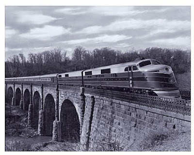
 B&O's Royal Blue crossing over the Thomas Viaduct
in 1952. Photograph by A. Aubrey Bodine, Copyright
Jennifer B. Bodine, Courtesy of AAubreyBodine.com.
http://www.aaubreybodine.com/gallery/default.asp?bc=07-093
 B&O's Columbian crossing the viaduct into Relay, 1949.
Image from Wikipedia.

circa 1950's. Photo B&O Railroad Museum.
in 1952. Photograph by A. Aubrey Bodine, Copyright
Jennifer B. Bodine, Courtesy of AAubreyBodine.com.
http://www.aaubreybodine.com/gallery/default.asp?bc=07-093

Image from Wikipedia.

Locomotive pulling Royal Blue passenger cars May 1972. Photo
taken by blog follower Walt Hiteshew. Thanks for sharing Walt.
taken by blog follower Walt Hiteshew. Thanks for sharing Walt.
Too bad they don't do excursions like that anymore. Wish I had
been there!

A closer view near the Relay end of the bridge. Photo by Walt
Hiteshew May 1972.
 CSX 3122 crossing the Thomas Viaduct into Relay. Photo by
Jeff L. March 22, 2014.
Jeff L. March 22, 2014.
The next 2 color photographs were donated by Jim Kleeman. A
widow that used to work for him gave him several slides taken by her
late husband Jack Shields. Jack used to go out with a few buddies and
photograph trains in the Baltimore area. Thanks for sharing these great
photos Jim.

B.&O.'s Royal Blue 56 passes over the Thomas Viaduct circa 1950.
Photograph by Jack Shields, courtesy of the Jim Kleeman
collection.
Photograph by Jack Shields, courtesy of the Jim Kleeman
collection.

Another B.&O. Royal Blue passes over the bridge in front of the closed
Viaduct Hotel circa 1950. Notice how well manicured the property
is across the tracks where the 2 lamp posts are. The 2 bushes on
this side near the builders monument are neatly trimmed as well. Even
10-12 years after the hotel and station closed down the B&O Railroad
still cared enough to keep it looking nice for the train travelling public.
Photograph by Jack Shields, courtesy of the Jim Kleeman
collection.
-----------------------------------------------------------------------------------------------------------
Photograph by Jack Shields, courtesy of the Jim Kleeman
collection.
-----------------------------------------------------------------------------------------------------------